Mt Holdsworth and the not-so-jumbo Jumbo Circuit
It was Wednesday, head down at work, deeply consumed in a piece of strategic transport planning when a message popped up: Keen for a big day out on Saturday? to which I replied like any sane human being would after watching the Banff Film Festival, and that is: yes!
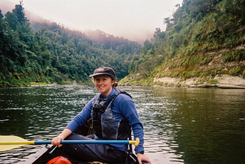
And so, a quick supermarket shop for some ciabatta and one brownie in the oven later, we were heading out the door just after 5am on Saturday. We had chosen to embark on a tramp that's typically done in three days, but one we wanted to do in nine hours, so we needed to be there for as much daylight as possible just in case we were slower than we thought. I napped for most of the drive, had a very mid steak and cheese pie from the Carterton gas station, before approaching the trailhead just as the sun was coming up. The gang headed off just after 7am after a two-hour drive from Wellington. This was my first tramp in the infamous Tararua Forest Park. I'd heard a lot about the gruelling uphills, wild winds, and epic tramping, so I was excited to experience it for myself.
Mt Holdsworth-Jumbo tramp is a CIRCUIT, yeahhh buddy!!! I feel like I do so many out-and-backs, so it was nice to see something new the entire way. It's 24km, and you can do it in three days, two days, or one day if you're - experienced, fit, comfortable with low visibility and strong winds, well-equipped with warm gear, and feeling gnar gnarrrr (look at me sounding like a cautious parent).
We headed out, following a well-maintained track. It was pretty gradual to start with before beginning to climb, crossing a few bridges and plenty of stairs to save us some leg strain. After about 30 minutes, as the sun was rising and glistening through the trees, one person in the crew started to feel sick. Luckily, they were only a quick scenic trackside vom away from feeling ever so slightly better. At that point, we decided to slow things down a notch and give them some time to decide whether they wanted to carry on. After a little while, we reached Rocky Lookout. We were extremely grateful to have absolutely pristine conditions, with clear 360-degree panoramic views. At the lookout we could see the huts we were aiming to bag in the distance and endless ranges of native bush stretching as far as the eye could see.
We then carried on and before long came across Mountain Shelter, which was pretty basic and nestled away in the shade. A nice spot to get sheltered from bad weather, but not exactly the most scenic lookout or lunch spot. From there, things got much, much steeper, but totally doable. This was probably the biggest mish I've done since breaking my ankle, so it was nice to use poles and transfer some of that force into my upper body. I was also testing out my new trail shoes. I'm used to hiking in boots with a big heavy pack, so the trail shoes and lightweight running vest, with storage for warm gear and the like, really made a difference. I loved flying up the hills and was grinning from ear to ear all day long. This section was truly gorgeous. The bendy beech trees were covered in moss, the ground was covered in moss, it was the most beautiful giant green spongey wonderland. There was plenty of birdsong, but not much bird spotting. The higher we climbed, the more satisfying it was seeing the vegetation shift into more alpine-style spiky plants, and despite the elevation gain, it still felt relatively sheltered as we reached Powell Hut.
Powell Hut was phenomenal. A true beast. Probably the second biggest hut I've ever seen, and the deck was huge with an epic view over the Wairarapa. I think it sleeps around 30 people across three different rooms. Because we were under a bit of time pressure, we only stopped there for about 15 minutes, smashed some food, and chucked on a few more layers because the temperature dropped surprisingly quickly the higher we got. We reached Powell Hut in about 2.5 hours, while the DOC sign suggested 4-5. At this stage, we were still assessing the weather and deciding whether to continue. Visibility changes incredibly quickly in this environment. The wind and clouds move fast, one moment you're looking at blue skies and the next you're surrounded by grey cloud. We all felt comfortable with the terrain, what we could see, and how warm we were, so we agreed to carry on.
This next section was probably the most fun. We spent a lot of time travelling along the ridge, and the vegetation was pretty cool in places. Our next goal was moving across and up towards Mt Holdsworth. We eventually reached the summit and its impressive trig point. We'd climbed all this way and... ummm... we could see absolutely nothing. Completely clouded over. Everywhere. But hey, that's the beauty of it, innit?
We then headed down for a bit and had a wee jog on some of the flatter sections before reaching a junction where we had options. We could head straight down, reducing the route to around 18km and making for a quicker day if anyone wasn't feeling great. That was our backup plan, so we all had a chat about how we were feeling and made the call to carry on. Not long after, we reached Mt Jumbo, which wasn't nearly as impressive as Mt Holdsworth, but it's always nice to bag another summit. Not far beyond was Angle Knob, which we could just make out in the distance. We chatted to some lads later who were talking about an old plane crash site that requires a bit of a bush bash from there. Sounds like a cool little side-quest adventure for another day. Indi also spotted a wētā on a rock, which was pretty cool to see.
There was more climbing, more descending, and by this point I was slowing down a wee bit compared to the rest of the crew. Since the ankle injury, I've become pretty focused on every foot placement, making sure I don’t slip. Before we knew it, we'd reached Jumbo Hut about six and a half hours in. There was already a crew there with the fire going, so it was a nice toasty place to smash some more food, have a drink, and rest the legs for a bit. The hut was much smaller than Powell but still a decent size, nestled amongst tussock and other alpine vegetation.
It got to the point on the trail I was least looking forward to... you know me... the downhill section, agh! And was it downhill. Just straight down through tree roots for what felt like forever. Don't get me wrong, it was absolutely beautiful and scenic and reminded me of scenes from some movies I've watched, but my brain was working overtime making sure I didn't roll my ankle. After what felt like an eternity, we eventually reached Atiwhakatu Hut. This hut seems pretty popular because it's not far from the carpark and the track is relatively flat coming from the other direction. There were a few cool bridges before and after the hut that I really enjoyed, and the river had a beautiful emerald colour that reminded me a bit of Mt Somers.
After another food stop, we sent it back to the car, walking some sections and jogging others just for a bit of fun. This was probably where I soaked up the most serenity I could, the birds, the trees, and the moss before heading back for the drive home. The crew were in great spirits, laughing away with plenty of smiles, and it was nice to look around and appreciate having people in your life who want to do the same crazy things you love doing.
All in all, it was such an awesome test of the body, the ankle, the fitness levels, and some new gear. It was nice being challenged by both the hills and the weather. I felt very, very happy all day and knew I was back where I belong: the bush, the mountains, te taiao.
I'd totally recommend this track as either an overnighter or, if you're keen for a challenge, as a day mish. As always, if you've got any questions, feel free to reach out.
Lots of love,
Roro xoxo


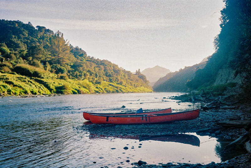
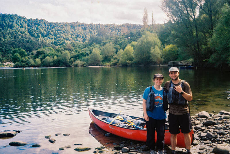
Paddling Taranaki's Tear Drops - The Whanganui River Journey
Each trip reminds me of a certain song, and after some careful brainstorming, I have settled on… “My Boy” by Marlon Williams. If you play this while you read along, you’ll get the feel… dodododo. This trip was very whimsy, very lovely, think kicking your legs while you wait at a bus stop, or waking up late as a teenager on the weekend to your mum whipping up pikelets with jam and whipped cream. I digress… the Whanganui River trip.
We started the journey with a train ride from Wellington to Palmerston North, because who doesn’t love public transport. We stayed in Feilding with the fam and got a relaxing escape from the “hustle and bustle”. We carried on past Taihape, Waiouru (Hi Angus!), and eventually made it to Ohakune (I’d never been there before, so that was cool). We ate some sammies and chatted to overseas travellers from Germany, Italy, and France. We took them up Ohakune Mountain Road to save them 10 km of walking and had a geeze at Tūroa Ski Field, which, without snow, showed off beautiful red volcanic rock. We then headed down, did a short walk to a waterfall, and started another at Waitonga Falls trailhead. We fast‑walked/jogged to the falls, then carried on to bag Lupton and Blyth Hut via some tarns before heading back down. Such gorgeous tramping with beautiful bush. When I looked out, I pictured how cool it must get in winter after snowfall. We then drove from Ohakune to Raetihi holiday park, about a 10‑minute drive.
The Raetihi holiday park was super handy. You can camp there the night before and they offer a shuttle service to and from the river, supply canoes and big tubs for gear, let you park your car safely while you paddle, and when you arrive back they have a big catered afternoon tea waiting. I highly recommend these guys, though there are quite a few other companies that do the same thing.
The Whanganui river journey can be a five‑day paddle starting in Taumarunui and finishing in Pipiriki. The first couple of days are mostly farmland, so we chose to skip this section as recommended online. Most people start at Whakahoro and paddle to Pipiriki in three days and two nights. If you’re looking to paddle the whole thing for the sake of completion, go for it, but the three‑day option is equally as gorgeous and relaxing.
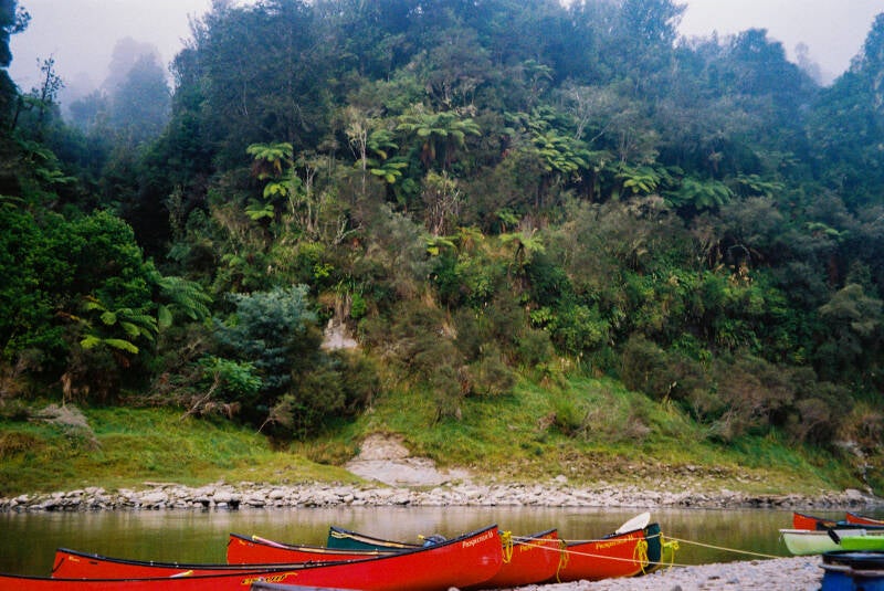
We started on Saturday with a van trip to Whakahoro and got a bit of an induction on how to paddle and direct the canoe. Luckily we had some kayak experience, so we both felt pretty comfortable on the river. Although, in saying that, it is a very flat and easily navigable river, and the rapids are very entry‑level. If you have no experience, the important thing is being comfortable getting tipped over and swimming to a bank, and having enough strength and fitness to paddle for eight hours a day. You don’t need to be super fit, but the more fitness you go in with, the more enjoyable your experience will be. We paddled the river while the flow was relatively low, so we had to put in a little more work. The river was bony in parts and the rapids were larger. When you go in higher flow, you get a lot more of a push down the river.
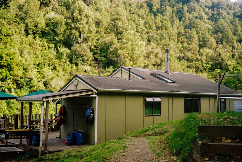
The first day we paddled from Whakahoro to John Coull Hut - 37.5 km, supposed to take 7–9 hours, but it took us 6 with a substantial lunch break (although we went a little faster than the crew we started with). There are quite a few campsites to stop at each day and tonnes of waterfalls along the sides to explore. We took a break for lunch and hauled our canoe up, tied it, and unpacked our tubs. This actually took a bit of energy and time. We realised from then on it’s much easier to have a day dry‑bag packed in the morning with food, snacks, sunscreen, and camera all easily accessible so we didn’t have to keep getting ourselves and the tubs out. If you want a break, it’s super nice to just lie down in the canoe in the water and look up at the sky, the trees, and the birds. We ate mostly buns and a LOT of chocolate, plus fruit, lollies, and nut bars. Before we knew it, six hours later, the time and kilometres had flown by and we reached John Coull Hut. You can camp or stay in the hut. It’s a rather large mish to get up to the hut because the sides of the Whanganui are not flat, you’re in this massive gorge with steep bushy walls, so the huts and campsites are always a steep uphill climb. Doing this while holding heavy tubs was hard, but we made it. The hut was chill, full of people over Easter, and good vibes all round.
On the second day we set out to travel from John Coull Hut to Tieke Kāinga Marae. Yes, you can stay at a fully functioning marae… I was sooo excited. This day was 29 km and was predicted to take 7–9 hours, but took us 6.5 including a walk to the Bridge to Nowhere. The track is 3 km each way, very well maintained, and a cool lunch spot. Well worth it in my opinion, so green and gorgeous, and nice to have a change from paddling. Plus I absolutely love walking places. We then carried on to Tieke Kāinga where we were greeted by the most lovely hut warden who had whakapapa to the marae and was full of history about the whenua, the awa, the ahi kā occupation, the iwi, the pou, and the ancestors. When the rest of the crews arrived, there was a pōwhiri welcome to the marae and we got to go inside the whare nui or as their iwi call it the ware puni. The roof of the ware puni was painted blue which I thought was odd and found out later it was blue to depict the tarpaulin sheets that were used as temporary shelters during the longest occupation in NZ history which occurred right there on the Whanganui. The warden told us about one of the many legends of the Whanganui where Tongaririo and Taranaki came into conflict over Pihanga. Tongaririo asked Taranaki to leave to ensure his tapu remained. Taranaki moved westward leaving a trail which he later filled with teardrops, leaving behind the Whanganui river. Tieke Kāinga was such a relaxing place to stay, heaps of tūī and banana trees left by Sāmoan and Cook Islands carvers. We played cards, ate chocolate, took photos, and chilled.
On the third day we set out for a shorter day to Pipiriki - 21.5 km, supposed to take 4–6 hours, and took us about 4.5. There were heaps of rapids this day compared to the previous two, including the infamous “50/50 Rapid”, which lived up to its name when we saw nearly half the boats tip over. This was the most exciting day on the river because there was the most rapid action, and my canoe partner continued to make threats of tipping us over and taking us down dire routes to scare me. We got through the 50/50 unscathed!
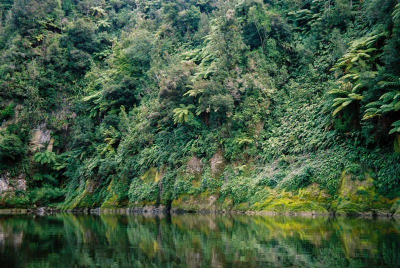
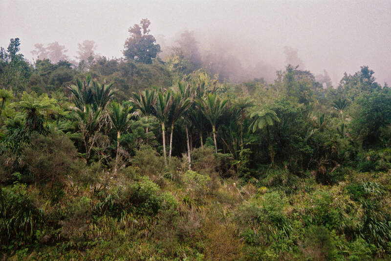
The Whanganui River leads you through deep gorges covered in native bush, mostly ferns: mamaku, kātote, whekī ponga and whekī, but also nīkau palms, beech, rātā, and rimu. The river was abundant with bird sound and sightings of pīwakawaka, ruru, tūī, and miromiro (tomtit), which we heard and saw every day. When you get into sections with no one else in sight, you simply hear the river, your paddles splashing, and the birds. It is truly such a peaceful trip, and it’s so good to think, ponder, have deep chats, rejuvenate, connect, and forget about everything going on and just be in the moment. My company was lovely, and it was such a nice way to catch up.
After breaking my leg in November, and spending months couch bound feeling frustrated that I couldn’t be out tramping, booking this trip in January allowed me to feel hope that I would be back out there soon. This trip lived up to all my dreams and it helped validate my absolute passion for the outdoors. I may not be back tramping just yet but I will be in a few months time and I'm so super excited to return to my happy place, perhaps with more appreciation than before.
Thanks for getting to the end… hope I didn’t bore you. If you have any questions about cost, booking, gear needed, level of difficulty, or anything else, please get in touch. I’d be more than happy to help you book this trip and give you certainty it’s something you can definitely do, because it was so awesome and I’d love people to have the same experience as me.
Lots of love,
Roro xoxo

Copland Track - The calm before the chaos
I swear the track isn’t that tricky, but, expect a twist…
Canterbury Anniversary weekend saw the Waka Kotahi Tramping Club, (aka Regan, Matty, and me), send it south to Glacier Country. Highlights included eating soggy Springfield Challenge chippies, copping some CDs at the Hokitika op-shop, and yarning about anything and everything in a very safe space (we align on nearly everything). We stayed at the Ivory Backpackers in Fox Glacier, which were pretty nice. It had a lovely spa, a cool kitchen bench (just trust me), and a surprisingly large collection of cliche quotes on the walls.
After a short drive from the backpackers we reached the trailhead, which was well signposted and easy to find. The Copland Track to Welcome Flat Hut via Architect Hut takes about seven hours, four to the first hut and another three to the natural hot pools and hut. We started our trot at 8:34 a.m., crossing the initial creek, Rough Creek. It’s a good indicator of recent rain because if you cannot cross it, you should turn around. Luckily it had been dry, so we crossed with ease.
The track was far more beautiful than I expected. I knew we would be following the river so I imagined a lot of metal underfoot, but instead the terrain shifted constantly through lush bush, river terraces, grassy clearings, tussock, and bouldery riverbed sections. It kept things interesting and we were constantly amazed. A sign led us to a river viewpoint where the Copland River meets the Karangarua, this was beautiful. Both rivers were a gorgeous milky light blue, fed by the glaciers and mountains above. The water had carved the boulders into distinct shapes and one looked like a giant wave. Other rocks had swirly patterns left by the flow. We passed waterfalls on both sides of the valley, some close to the track and others dropping from cliffs across the river. I loved all the little bridges, even the wobbly ones. After just under four hours we reached Architect Hut for lunch and hid inside to escape the sandflies. Pro top - definitely bring repellent.
On our way out we chatted to a few lads sitting on a flat patch of grass. I thought it looked like the perfect tent site until I noticed the “Keep clear, helicopter pad” sign. They complimented my gandalf stick, especially compared to Regan’s Dr House cane, which I teased him for. What is the use in that thing, right?
Well…
About thirty minutes later, with roughly three hours left to Welcome Flat Hut, while stepping down a small rocky section, my left foot slipped and twisted and I dropped instantly. The pain hit hard and I was winded and in shock. I took painkillers immediately because I knew it wasn’t a light roll your ankle and keep going type of situation. Regan and Matty switched instantly into rescue mode and propped my foot up, gave me things to rest on, and kept my spirits up. We decided to hobble back to Architect Hut to reassess. Regan carried my pack like a trooper while Matty stayed close behind as I limped along with the mighty Dr House cane while cursing the whole way. It felt like forever.
At the hut we found a couple already settled in, one of them was injured as well, and they told us we couldn’t stay. By that point it had become pretty clear I wasn’t able to walk out. I had to activate the PLB (personal locator beacon). Considering the terrain ahead, including boulders, bridges, and creeks, I knew a ground team would not be coming with a stretcher and mule. With the helicopter pad right there and plenty of commercial aircraft in the area, a helicopter was the most realistic outcome. I wanted to set off the plb early enough to give the crew time to coordinate and to allow the pilot to arrive before conditions worsened. So I pulled it for the FIRST TIME EVER. It was daunting, but the flashing light was also a huge relief.
Before long, Ken, the coolest and kindest and chillest dude, arrived in his little helicopter. He told me he would get me sorted and that Regan and Matty could come too. After a quick hazards briefing we lifted off and flew over the valley we had just walked through. The views of the rivers and mountains were unreal. Ken dropped us back at the trailhead carpark and we spent one more night at the backpackers before heading back to Christchurch the next day.
I figured my ankle was sprained, but on Monday I went to the doctor to be safe. The x-ray showed a spiral or torsion fracture of my fibula. Cast and crutches for six weeks, which is a massive shame. But the recovery time does mean rest, which is not usually my strong suit, plus time to plan my next adventures and space to appreciate how lucky I am to have a healthy body that normally carries me to beautiful places. I’m also feeling super grateful for all the lovely people in my life who help me when I need it most, appreciate you cuties. To the mountains, rivers, birds and bush… i’ll be back!
Lots of love,
Roro xoxo


Granity Pass Hut via Mt Owen Track
If you’ve got time for a longer drive or you're hanging out in Nelson, this one’s for you!
A solid climb, stunning bush, heaps of bird sound, some epic rock features, and when the clouds clear, views on views of native covered hills all the way out to sea.
We were keen for a cheeky summit, a bit of snow, a mission out of Ōtautahi, and some proper bush time, so this walk ticked all the boxes. The aim was to get up Mt Owen, and with ice axes and crampons packed, we were fizzing. We didn’t reckon the snow cover would be too wild but turns out we were in for a surprise.
It’s about a 6-hour drive from Ōtautahi, but we didn’t mind, there were good tunes, heaps of singing, and even more yapping. We spent the night at Siberia Flat Campsite (basically the same as Courthouse flat campsite at the trail head), just a grassy patch surrounded by bush.
The next morning we kicked things off with a swing bridge and had two options: Ridge Track or Blue Creek Track. We picked the Ridge Track and yeah… it was steep. Just a big ol’ punt up the hill really. We gained elevation fast!
The weather wasn’t great. Low vis, cold, and then the sleet started. We got properly wet, then cold. Not long after, thunder and lightning kicked off and we got a bit rattled. We were about 1.5 hours in by that point, sitting around 900m, with a thin snow layer already down and still 1000m to go if we wanted to hit the summit.
That’s when we realised the summit might be a no-go. But we kept sending it, figuring we’d reassess if it got worse. We both had film cameras and kept stopping for shots, which was worth it, but getting our gloves back on with frozen hands was a mish.
After a couple of hours we hit a big snowy knob clearing, lost the trail markers for a sec but found them again. Then came a short, kinda sketchy downhill bit. Lots of roots and rocks, super slippery, and definitely not a place you'd want to fall. With the snow around, we were pretty cautious and a bit slower through the marble bluff bits.
We were also watching out for avalanche risk across the rockier faces. Eventually we dropped back into the bush, this time, tussocks, and neinei (truffula trees), compared to the beech and ferns we had at the beginning. This section was so pretty. The snow underfoot, blue skies starting to peek through, and the views of the rock formations and snowy mountains were stunning.
Granity Pass Hut (a 12-bunker from 2009, sitting at about 1250m) is in such a mean spot. No fire though, and when we arrived, we were absolutely soaked and freezing. But there was a wee hot water bottle which saved the day. We got warm, had some kai and a hot drink, and settled in.
We had the hut to ourselves which was sick. After deciding the summit wasn’t worth the sketch factor (and probs zero views anyway), we just chilled, ate chocolate and lollies, and had some essential boogies when it got too cold to sit still.
The next morning we woke up to absolute mint weather. If we’d gotten up earlier, we might’ve made a dash up part of the summit, but ended up cruising back to the car instead. Because the weather had cleared, we got all the views we missed the day before. Lush hills, blue sky, and heaps of bird life. Loud kea flying over, plus korimako, pīwakawaka, miromiro, and one native bird I couldn’t figure identify. The snow had melted heaps, which made things way easier.
We took the Blue Creek Track on the way back and it felt like a totally different walk. Way less exposed, super lush undergrowth, and it kinda felt like it hadn’t been walked much over winter. Some parts of the track were pretty narrow. So many ferns in this bit too, and we followed a river near the end that had this beautiful greeny-blue colour.
We also passed a bunch of old mining relics. Didn’t see a single person the whole trip. The first people we saw were back at the carpark about to head off.
Overall, highly rate this walk and this hut. I’m super keen to go back and reach the summit. It’s a bit of a punty slog, but 100% worth it for the views. The bush is unreal. Such a good place to get zen.
We were quite a bit quicker than DOC times on the way up, and maybe bang on (or a little slower) on the way back. Great company, great sendy mish. Heeckeey yeaeehaww.
Lots of love roro xoxo


Pinchgut Track to Pinchgut Hut
Rachel was on the money!!
She suggested Pinchgut Hut - “short drive from Ōtautahi, a 3-hour trek, bit of a challenge, and a nice wee hut to top it all off.” I was sold!! After spending Friday snowboarding at Porters, my ass and abs were sore, so heading off at 12 suited me perfectly.
We got a bit lost on the drive… Putting “Pinchgut Hut Track” into Google Maps directed us straight to a NO ENTRY forestry block. Luckily, we had some service and were able to re-route. If you’re planning on doing this tramp, you’ll want to head down Taaffes Glen Road and along a gravel track before parking at the trailhead.
The tramp starts with a crossing of the Okuku River, which, as you learn quickly, is a wide channel known to rise fast after heavy rain. Luckily for us, the river level was only about mid-thigh deep. Environment Canterbury has a useful website that gauges river flow if you want more of an idea before heading out. If you can’t cross the initial section… it’s game over buddy!
The first section leads along a 4WD track, passing an apiary we quietly avoided. After that, the track becomes quite undulating and follows the river. At times, you’re walking right beside the water, and ten minutes later, you’re deep in beech forest looking out at the native-cloaked Okuku ranges. This tramp had gorgeous bird sound throughout, mainly korimako and pīwakawaka, but we also spotted a super unfazed kererū and a chirpy ngirungiru (South Island tomtit).
There is a nice waterfall not too far in. It’s a great place to stop and have some snacks. We were warned of a few slip sites to manoeuvre but realised these notices were a bit out of date. The slip sites had a decent amount of vegetation regrowth, nothing sketchy.
My fav part of the tramp was a section where the track leaves the bush and drops onto the riverbed. There are heaps of big boy boulders and multiple routes to pick from which made it a bit of fun. This part is a few hundred meters long before the track climbs back into the bush.
Some of the climbs were certainly not easy, had us puffing, rosy-cheeked and sweating. After a decent uphill section we spotted the hut through the trees and headed down. Built in 1983, the hut is nestled right next to the river and in mint condition. It’s actually the second hut to be built at this site, not sure how historic the original was?? It had seven mattresses, but there was definitely room to squeeze in a few more.
We shared the hut with a couple of dads and their kids. They started the fire as we arrived, which kept us cozy all night. We took a look at the stars before bed and they were absolutely stunning. I hadn’t seen stars that good in a long time.
In the morning we packed up and sent it out. We had to take it pretty careful on some of the muddy downhills to avoid slipping. We were blessed with blue skies and sunny weather both days.
After an epic mish we got some pies and sweet treats from the Artisan bakery in goon and my god were they delicious, highly recommend this place. The doc sign says 2hr30mins and the website says 3hrs, it took us 2hr16min on the way there and 2hr10min on the way back. This one's great if you’ve done a few beginner tramps and you’re looking for a nice next step or if you want to be amongst gorgeous bush in a short amount of time.
This route is challenging enough to feel earned but short enough to smash out in a weekend. You get a mighty river, gorgeous bush and birdlife, a great hut, and some classic kiwi remoteness all within a short drive from Ōtautahi.
No guts were pinched throughout this journey. Food wasn't rationed, it was in surplus and snacks were shared. We weren't held hostage and fed bread and water. Yikers!
P.S my company on this trip was epic, 3 sexy, strong, smart and wholesome wāhine <3
Hit me up if you have any questions. Love roro xx


1 Night on St James
Fighting the stigma of St James…
I’ve been told the St James walkway is a great route for families and beginners, but also that it’s boring and lacks anything spectacular. Well I say… wrong!
A quick stop at New World for a cheeky steak and cheese pie and a 2hr drive from Ōtautahi was all it took to reach Boyle campsite. I pondered which end of the St James Walkway we should attempt. I’ve heard the Cannibal Gorge end is known for car theft and frankly a smashed window while out tramping in January was enough for me to protect Caroll at all costs. Boyle campsite has a big whopping camera watching over the ngā motokā so it felt safe. Our plan was to walk a bit, soak up the ngahere, hang out with the birdies, eat a sh*t tonne of salami and cheese and decide what hut we’d like to stay in.
The first section was about 3 hours. We wandered through beautiful beech, while numerous pīwakawaka, ngirungiru (south island tomtit) and toutouwai (south island robin) kept us company. The track has some gradual climbs and descents, nothing strenuous. This section certainly had some quite muddy and boggy sections that some thoughtful manoeuvres could avoid, in my case, well, maybe not so much. After crossing the Boyle river a few times via suspension bridges we made it to Magdalen Hut, a standard 5-bunk hut built in 2008. It’s double glazed, has a nice deck and great to spend the night if you’re looking for a short mission. There’s heaps of land around the hut to tent in summer too.
After eating half a log of salami we kept on trotting. The next section was same same with slightly more climbing. We came across a wee wash out but a fairly worn track had been made further up and then, after some more climbing, bammm!!! We had made it up to an awesome clearing, an extensive sight of the valley ahead, the mighty awa, the snowy peaks, and nestled in the bush, old wee Boyle Flat Hut. As we sat in the hut with a Hummingbird coffee in hand we contemplated whether we stay put or mish up to Rokeby Hut for the night. The inner hut bag psycho in me was really pushing for the mish but after adding some things up we decided to conquer it the next morning. We had Boyle Flat Hut, a serviced 12-bunk hut built in 1980 all to ourselves. Indi managed to keep the fire going for a solid 4 hours which was a massive feat considering most of the wood was damp. Something so special about chatting for hours to candle light in the bush, all cosy and warm by the fire.
The next day, after a 12 hour sleep… we mished it up to Rokeby hut, a basic 3-bunk hut. When they say basic, they um, kind of mean basic. This gem had canvas bunks, and no mattresses. We were SUPER PLEASED we chose to stay at Boyle Flat Hut, all the more cosy. Rokeby is definitely more of a last resort or maybe one to enjoy with a lot of whiskey. The section from Rokeby Hut back to Boyle Flat Hut crosses some minor side channels and tussocklands which were a nice change from the beech. I cooked up some porridge and we then headed back to the car park where we came from, a 6.5 hour journey according to DOC times, which took us about 4.5. We saw some pūtangitangi (paradise shelduck) in the valley and unfortunately flocks and flocks of canada geese, which came with tonnes of poop.
The trapping in this section of St James was of note, tonnes of automatic traps, big ups whānau, keeping the manu happy!! Some of the land near Magdalen Hut is private land… farm land… cows… which left big pats on the trail. Pretty uh lame, but we dodged them, well… all but one. Besides that, epic tramp, awesome company, beautiful bird sound, 3 bad boiis bagged and some time to rejuvenate, reflect and contemplate whether I should spend by 20s studying, working, travelling, having babies, or something else extraordinary or if I should just chill out because life doesn’t end when you turn 30. WOAH sorry for the big sentence.
Hit me up if you have any questions. Love roro xx


Casey-Binser Saddle Route
Tramp Summary: Frozen boots, snow, white capped peaks, beautiful bustling bird sound, toasty fire, big climbs and rubbish?
The Casey-Binser saddle route is about a 40km trek after having to retrieve the car. It’s no easy feat, long days and plenty of climbing. Nothing too tricky to traverse and super awesome to do in winter with lots of snow on the surrounding peaks. The DOC website tells you to start at Andrews Shelter, with casey saddle followed by binser saddle the next day. We did it in the opposite direction to have the best chance of good weather as we crossed the saddle. Luckily the weather was great with really no rain at all. We all agreed this was the best direction regardless of the conditions. This way the more difficult sections are at the beginning of the day.
We had to tackle a super brutal climb at the very beginning of the tramp which had us all puffing hard, and me, well, I was having secret “hell yeah I feel so alive, i love uphills so much” moments. Bird sound was just gorgeous, super abundant and each pit stop saw us have greater views which helped with motivation. I was pretty grateful we didn’t have to go back down this way. It’s pretty steep in places and I can imagine it would be very slippery when wet.
After this we were rewarded with a lovely snow section at the top which was so so gorgeous. We stopped to eat our Sheffield pies for lunch which were glorious and then sent it down. The descent felt quite safe with plenty of tree roots and rocks for security and didn’t take us too long. I struggled a wee bit with a short rocky section just before we got to river level. Some of the rocks were quite loose and I was scared I might slip as we really only had matagouri to hold on to, ouch! Was great to finish this section, I HATE DOWNHILLS XOXO
When you’re at the bottom there’s quite a nice spot for camping. After this there’s a large fairly flat 4wd section with lots of POO and weirdly rubbish? We picked up quite a few pieces of rubbish, mainly food related, and wondered if it had been left by trail runners or trampers… a bit disappointing to see. We passed through some small terraces and pretty springs with clear water and even saw a lil fishy!! We then made it to the hut, three of us with wet feet and one who managed to keep dry, rumour has it a little parkour was involved.
The hut was well located with 360 views of snowy mountains and beautiful bush. It had a sexy deck looking out at the river valley. It’s a standard 12-bunk hut and there were 11 of us there for the night. Most of us had packed tents just in case and there were definitely some good spots. A midnight trip to the toilet blessed me with a beautiful site of the stars, a matariki must have. We were pretty lucky to stay in the hut as the temperatures were very low and a massive frost appeared overnight. We woke up to frozen boots and socks that we’d left outside, silly us, we know, we’ve learnt our lesson. The hut is a short 1.5hr walk from Trust/Poulter hut if you wanted to stay there instead, or chuck on another night.
The second day started off pretty chill, we took it easy as the taps froze overnight so our water storages were low. We then started another big climb. The ascent was much more gradual then the day before which was a relief as some of us had sore legs. We found a nice stream to fill our bottles and had a wee break. Then more climbing with lots of boggie sections, a few stream crossings, meandering our way from sub-alpine ridges, through bush to tussock flats until we made it to the saddle. It was beautiful, nice and wide with great views all around. We stopped there for lunch, although we agreed it was maybe a little windy. Still glad we did as the temperatures started to drop and clouds turned grey.
We then wandered back into the bush, and had some small ascents and descents. We came across quite a cool grove of old and quite large beech trees which was nice. The last section was down, down, down and we took that slow and steady to ensure we didn’t make mistakes while we were tired. At Andrews Shelter we dropped our packs and walked along the gravel road for 30mins to the car.
A great 2-day trail that can be made into a 4-5 day or even longer route with plenty of little huts, bivvies and campsites after reaching Casey Hut. Important to check the weather carefully before embarking on the saddles, especially in winter and spring. It took us 7hrs to get from the car park to Casey Hut via Binser Saddle and about 8.5hrs from Casey Hut to Andrews Shelter. These are long days so prepare well and leave early. Highly recommend this trip, gorgeous views and some of the best bird sound I’ve experienced while tramping.
Hit me up if you have any questions. Love roro xx


Mt Brown Hut Track
Ohhh Mt Brown you beautiful little orange box full of rats!!!
If you’ve been tramping with me you’ll know I’m an absolute fiend for uphills and curse the entire way down. This track was a decent climb which made it an epic first day, but the second day was a relentless downhill which made me a bit cranky.
We arrived at the carpark around 1pm, after a 3hr 40 min drive from Ōtautahi, Christchurch. On the way we took the opportunity to have a West Coast pie on the Hokitika beach front before checking out the Hokitika gorge walk. It’s a decent mish from Ōtautahi so well worth the early wakeup to check out some other spots on the way. The car park is super close to Lake Kaniere and Dorothy falls too, highly recommend checking them out. There were four other cars parked when we arrived, and the hut has four bunks so we expected a crowded party at the top. To our surprise, everyone we passed was heading up and down in the day so we ended up having the hut all to ourselves. The sign says 4 hours in both directions and online we read 3-4 hours. It took us 3 hours up with plenty of breaks and view stops, and 2.5 hours down. If you just had a day pack you could definitely head up and down fairly quickly.
The track isn’t maintained by DOC, but all things considered was in pretty good nick thanks to the Permolat Trust. It starts off flat and wanders straight into gorgeous bush. There were a few fallen trees that my short legs couldn’t get over so I had to get all primal and crawled underneath on my hands and knees, felt very in touch with the whenua. It then crosses a wee little creek which was gorgeous. This is the only water body you have to cross which is gangsta and means you can do this track at any time of the year, a bit of a rare case for the wet and wooly west coast!! After this it’s a hectic climb up so I was in heaven. There was a cute and very friendly lil pīwakawaka that followed us most of the way up. Heaps of ferns at the beginning and cool shelf fungi and moss everywhere. Some of the roots on the trail seemed so perfect as hand holds to help you get up which made things easy.
As you climb up you get a more extensive view of Lake Kaniere and the coastline as well as the surrounding bush covered foothills. There were tonnes of horopito bushes and trees about half way up and they were so pretty and pink. The second half of the track was super fricken boggy which was honestly pretty fun. The mud had a good clay composition so if you got the right footing you could avoid being knee deep in mud. Just before you’re above the tree line there are tonnes of mountain neinei that look like truffula trees from the lorax, which are so funky. By the time we got to the alpine zone it started to really cloud over so visibility was pretty poor. It evens out a lot at the top and that’s when you know the hut is very close. Unfortunately there wasn’t much of a view at the hut because of the cloud but we got to see glimpses of the view on our way up.
The hut was very cute, 4 bunks, a little table with two stools for about 4 people, a bit of room on the floor to pop sleeping mats if there were more of you wanting to stay. A nice fireplace called ‘little cracker’ which made me laugh. There isn’t any supply of firewood for about 30 minutes so if you want to have the fire going I suggest collecting some wood before you ascend the alpine section or lugging some up in your pack. There was water outside the hut but the tap gets frozen in some parts of the year so make sure you boil some water before bed so you’ve got some to wake up to in the morning. The hut has a gorgeous deck so we had a few west coast hazys while we watched the west coast hazzzee. We were told rats hangout in the hut lining and well when we shut our eyes and all was quiet the rats decided it was party time. They had a bloody heck of a time dancing about, couldn’t see them and they weren’t in the hut but knowing they were in the ceiling was kinda feral.
The hut’s pretty exposed and can get real windy so make sure you check for high winds before you trek and maybe avoid it during those times. The hut is bookable so give poor ol DOC some money and book ahead of time to avoid getting caught out without a place to sleep. There’s def room to tent but it gets pretty frosty and cold so I'd only really do this in summer.
Any questions, hit me up. Love roro xxx


Create Your Own Website With Webador